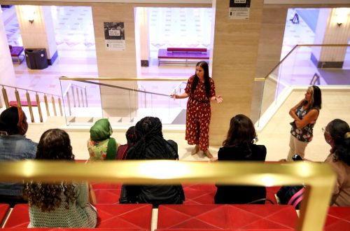
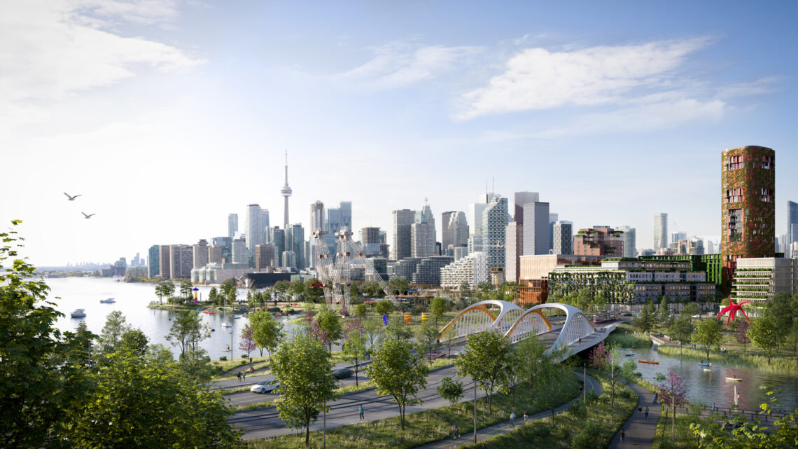
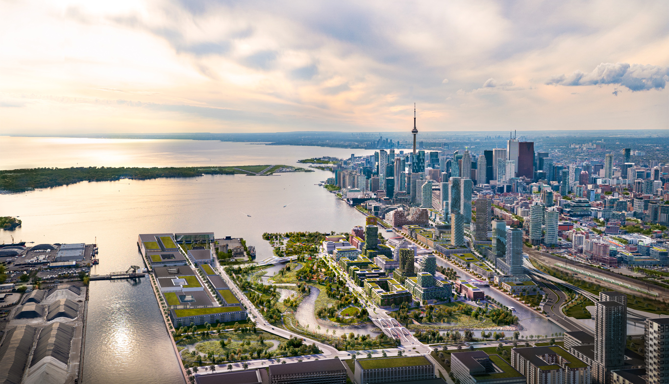
Natural landscapes can often re-energize, bring peace of mind, and help people feel centered within their life. In larger, busier cities, where manmade infrastructure is sprawling and the population is diverse, many times nature is not as accessible to most. Though sustainable practices that help preserve nature may not often be prioritized, in Toronto, an organization known as Waterfront Toronto has set out to put people first by reconnecting them with the waterfront in the design of projects that are environmentally and economically sustainable. As part of that initiative, the organization plans to debut one of its larger-scale projects, called the Port Lands Flood Protection Project, to the public in 2024.
Created in 2001, Waterfront Toronto’s mission is one of revitalizing Toronto’s waterfront area—land that is approximately 800 hectares, or roughly 2,000 acres—along the waterfront from Dowling Avenue to the west to Coxwell Avenue to the east. The organization works to tackle big issues that occur along the waterfront, projects made possible by collaboration across all three levels of government—federal, provincial, and municipal—as well as partnership with property developers, conservationists, and community groups to improve the ecological health of the waterfront and create conditions for next-generation job creation.
Since its formation, Waterfront Toronto has worked toward creating about 40 hectares of public space, or more than 100 acres, in the city. By 2024, 30 of those 40 hectares on Toronto’s waterfront will be completed and open for public use as part of the Port Lands Flood Protection Project, a project that has been in the works for decades.
In the event of extreme weather, floodwaters from the Don River had the potential to overwhelm portions of the Port Lands, South Riverdale, and Leslieville. To protect Toronto’s southeastern downtown area, the Port Lands Flood Protection Project will reconnect the Don River to Lake Ontario by creating a new, naturalized river mouth. The area surrounding the Don River has been vulnerable to flooding and in turn, underused, undeveloped, and industrialized for years before a citizens group launched the Task Force to Bring Back the Don in 1989. Two years later, in 1991, the City of Toronto published a book from the task force called “Bringing Back the Don,” which explained the vision for the river’s revival. As a plan to revitalize the mouth of the Don River and protect the surrounding area from flooding, the endeavor became formally known as the Don Mouth Naturalization and Port Lands Flood Protection Project, later shortened to the current name, Port Lands Flood Protection Project.
Waterfront Toronto, the City of Toronto, and the Toronto and Region Conservation Authority, or TRCA, have worked on many initiatives and studies during the long-term planning process for the Port Lands project, one that has spanned more than a decade. These studies include: the Don Mouth Naturalization and Port Lands Flood Protection Environmental Assessment, or DMNP EA, which was established in 2005 and approved by the Ontario Ministry of Environment and Climate Change in 2006, signifying the formal beginning of the study; as well as the Lower Don Lands Master Plan Environmental Assessment; precinct planning for Cousins Quay, now known as Villiers Island; the Film Studio District; and the Port Lands and South of Eastern Transportation Master Plan EA and the Port Lands Planning Framework, or PLPF.
“[The Port Lands Flood Protection Project] was never just about flood protection, it was about restoring some of the natural ecology that would have been present along the Don River before industrialization changed it. It also promotes development, not just by flood protecting, but by putting the river as a centerpiece for new development communities on either side. It is all three of those things: flood protection, naturalization, and urbanization,” said Christopher Glaisek, chief planning and design officer at Waterfront Toronto.
In 2007, Waterfront Toronto launched an international design competition to create a concept design for the project. The organization was in search of a plan that would encompass habitat creation and flood protection, while also addressing urban design, transportation, naturalization, sustainability, and other ecological issues. The winning design, which provided the framework for the preferred alternative through the DMNP EA, was created by Michael Van Valkenburgh Associates Inc., or MVVA, a multidisciplinary landscape architecture firm with offices in Brooklyn, New York, Cambridge, Massachusetts, and Denver, Colorado.
“We were aligned with Waterfront Toronto’s competition brief to create flood protection in a way that re-naturalizes the site as a landscape. The way we approached [the project] really was to understand the science behind it so that we could also create a riverfront park that works as a natural system,” said Emily Mueller De Celis, partner at Michael Van Valkenburgh Associates Inc.
The $1.25 billion in municipal, provincial, and federal funding was awarded to the Port Lands Flood Protection project in 2017 and in December of that year, construction of the project began; some of the first steps being to address contamination to the site from former industrial uses and excavation of a new kilometer-long river valley and new mouth for the Don River.
“Within the first piece of that was the soil, and [figuring out] how to take a post-industrial site with a lot of contaminated brownfield conditions and work through the government, the federal regulatory process, of being able to move soil, treat it, and take it off site when needed. The big takeaway is that about 1.3 million cubic meters of soil had to be excavated from the new river and flood plain and managed onsite,” said Herb Sweeney IV, principal at Michael Van Valkenburgh Associates Inc.
“That is what provides the flood protection, by raising the elevations of the future development precinct, by creating a valley condition with flood protection landforms that prevent extreme storm waters from moving out into the adjacent Toronto neighborhoods—that is all part of what starts that first layer,” Sweeney added.
Sweeney also said that the engineering to create a more stable river was driven by ecology, working with the hydrologist and geomorphologist to study the flow of the river waters, and identify where some areas may need a more typical, harder armoring approach of large limestone blocks. In areas where the river’s flow is more subtle, however, the goal was to create habitat while also stabilizing the bank edges. A majority of the river will also be treated using plants to stabilize the water’s flow, or in areas with a stronger stream, large wooden crib walls anchored to the banks of the river will also be implemented.
During the excavation process, the construction team also found seeds in the peat layer of the ground of local plant species believed to be about 100-years-old and that have not been actively growing in the area in recent times. Once exposed to the sun, the seeds germinated. David Kusturin, chief project officer at Waterfront Toronto, said that they plan to do a historic plant restoration and are in the process of having the seeds genetically tested to confirm their age so they can eventually harvest the native species and add them into the planting palette of the river.
“This is the first project of its kind anywhere in the world,” Sweeney said. “One thing that is highly unique is that the landscape architecture team is leading an engineering process, and it is a massive engineering process. I think the outcome of this project is going to be so much different than if it was led and dictated primarily by engineering. It is really going to be about how humans can re-occupy and get to the edge of the Great Lakes, to get to that access to water in a very different and meaningful way than if it wasn’t led by a landscape architecture office.”
Sweeney also indicated that in the initial plans for the project, the river followed a large, graceful swoop through the current layout, rather than a hard, 90-degree angle. During the design process, the team visited analog river mouth sites in the greater Toronto area, studying the meander of the river mouth and the wetlands associated with them.
“We started to question ourselves, saying: ‘We realize that we need river channel banks for base river flows; we need to discharge the flood waters when they come so they don’t back up and overtop the river valley banks, but how do these other systems work?’” Sweeney said. “With our ecologist and hydrologist, we said: ‘You cannot flood out the city, but you can flood into the wetlands. You can overtop the river channel banks separating the river from the wetlands, which we have in the project, and use those wetlands that are lake-connected as a relief point.’ When we changed our thinking and started modeling it, what we realized was we didn’t need this big, engineered solution of a superspeedway exit for the river, we can add meanders into it.”
With this new understanding, they proposed a design for the river that had an S-turn meander in the center of the project. At first, the proposal was refuted, thought to possibly cause more problems, but Sweeney noted that once they walked the team through the engineering of how the new design would maintain flood protection and open an opportunity to reconfigure the parks above the top of the bank from a consistent linear park system to a more continuous, larger section of the park, it became what is now the current design for the project. The larger section of the park formed by this new design created more open space for what will be a nature play area.
“We would have never had the space for that if we wouldn’t have pushed the boundaries on the engineering and had consultants who were willing to think creatively and outside the box. If it was the engineering approach, it would have stayed the same as it was in the planning phase,” Sweeney said.
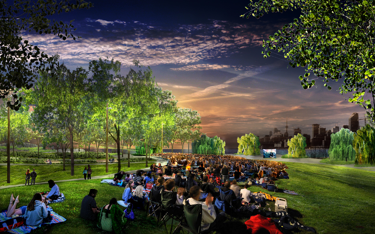
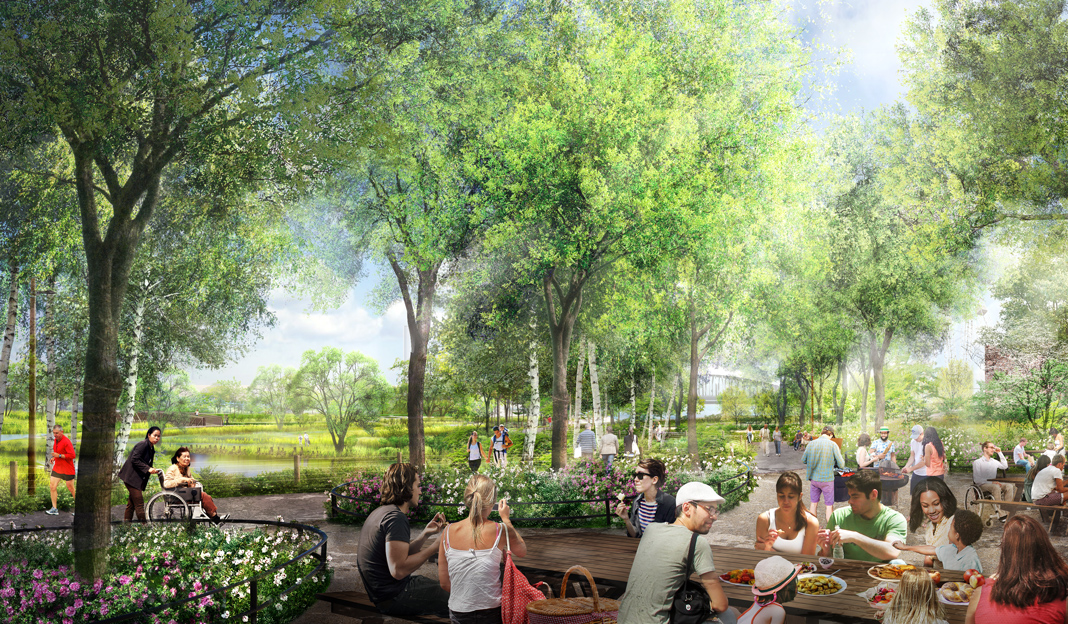
Parks implemented as part of the Port Lands project will also offer visitors a range of programming to engage with one another and with nature.
“This is a once-in-a-lifetime opportunity for Toronto to create a new, large park. The project has three different parks: Promontory Park South, River Valley Park North, and River Valley Park South. The idea is that they all work together in concert to create one large landscape experience and one large park for the city of Toronto that is really connected to the valley system, but is also connected to the waterfront,” Mueller De Celis said.
The new park system is intended to promote human engagement with the water, such as through opportunities to fish, kayak, and canoe on the river. In Promontory Park South, there are plans for Canoe Cove, a series of islands accessible to people canoeing through space carved out of the dock walls.
There are also plans for expansive lawns for gathering, recreation, and larger events; and a series of dog parks, walking paths, picnic areas, and playgrounds will also be integrated in the area’s design. One of the larger playgrounds, made possible by MVVA’s river design that allowed for reshaping of the land, a nature play area will have play structures rooted in the natural environment, designed to engage children’s imagination. It will comprise an exercise circuit and tie in more conventional play structures as well as nature-based equipment, such as swings and climbers.
“From a person-perspective, a lot of the comments and the interest from the public was they want to be immersed in nature. This allows them to have that right at the front door of Toronto, and it will become one of the largest urban parks that the city has. It is going to be a big change in a positive way for the city,” Sweeney said.
Although much of the original site needed to be carved out to create the river, a few elements will remain as a reminder and celebration of the site’s heritage. One of the cranes formerly utilized in distributing material to-and-from the ships on the Great Lakes will remain onsite as a monument of the activity that used to take place there. An older fire hall has also been lifted and relocated within the park and will be renovated to a park facility that will hold programming for the park, which is still being determined.
The river’s new shape through the Port Lands also helped realize Villier’s Island, which has been in the works since 2013, the planning of which a collaborative effort between Waterfront Toronto, Urban Strategies, and the City of Toronto. Villiers Island will provide homes, jobs, and community amenities for thousands of people. The island will also aim to be one of the first climate-positive communities in Canada, meaning it is designed to eliminate greenhouse gas emissions in-and-beyond its own community by producing more clean energy than utilized.
Kusturin noted due to the area’s previous history of heavy industrialization, it does not have the infrastructure and services a mixed-used commercial neighborhood requires. Part of the Port Lands project will incorporate new water, sewer, sanitary, storm, and hydro services, as well as rebuild the existing roads—Don Roadway, Commissioners Street, and Cherry Street—and build bridges for travel between the newly formed island and the mainland. The implementation of future LRTs, or light rail transit, will help new residents and those that will be working in the neighborhood get around the island.

Ken Dion, project director of Port Lands Integration at Waterfront Toronto, indicated a few other highlights emerged from the project, such as the unearthing of a large portion of the original Toronto government breakwater that was instrumental in forming the industrial landscape that was previously the Port Lands. Also, early on in the Port Lands project, the creation of wetland habitat allowed for the monitoring of fisheries, which showcased significant increases in native fish abundance and diversity, emphasizing the benefits to wildlife populations.
A process comprising many moving parts, the Port Lands Flood Protection Project has taken the work of a vast array of specialists to bring it to fruition. Some of the consultants comprise: RJC Engineers, structural engineering; Smith + Andersen, electrical engineering; Entro, wayfinding and signage; LMDG Building Code Consultants Ltd, code; MinoKamik Collective, indigenous design; Reliable Reporting, play; Dougan & Associates, wetland and meadow; ERA Architects, heritage architecture; WSP, civil engineering; and Vermeulens, cost estimating, based in Canada. Others included: Domingo González Associates, lighting; Jacobs, earthwork, environmental, and geotechnical engineering; ETM Associates LLC, operations and maintenance; Geosyntec Consultants, geotechnical engineering; LimnoTech, hydrologic design; GEI Consultants Inc., marine and coastal engineering; Inter-Fluve, ecology; Olsson, soil science; and Hines Inc., irrigation, of the United States.
“This whole territory, I think, is not on most Torontonians’ mental map of the city at all. For most people, this almost doesn’t exist, they don’t know it is there. The river project is going to fundamentally change that; everyone is going to know about it when it is open and want to come and see it. I think the whole Port Lands will take on a new role in the psyche of the city, and then the incredible naturalization component of this is going to lead to a new approach to urban development,” Glaisek said.
“We are going to see this become one of the greenest neighborhoods in the city and I don’t just mean it will be energy-efficient and low-carbon, but I think nature will start to inform a lot of the architecture and the hard landscapes in the area. It will create some new relationships between nature and downtown intensification,” Glaisek added.
First published in Great Lakes By Design: In Flight, 2022
Text: Brenna Buckwald
Photography: Provided Courtesy of Waterfront Toronto